THE MEANING OF LE MENEC (PDF)

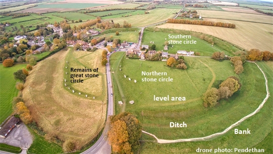
This paper proposes that an unfamiliar type of circumpolar astronomy was practiced by the time Le Menec was built, around 4000 BCE. This observatory enabled the rotation of the earth and ecliptic location of eastern and western horizons to be known in real time, by observing stellar motion by night and solar motion by day. This method avoided stellar extinction angles by measuring the circular motion of a circumpolar marker star as a range in azimuth, which could then be equated with the diameter of a suitably calibrated observatory circle. The advent of day-inch counting and simple geometrical calculators, already found at Le Manio’s Quadrilateral, enabled the articulation of large time periods within Carnac’s megalithic monuments, the Western Alignments being revealed to be a study of moonrises during half of the moon’s nodal period. Le Menec’s Type 1 egg is found to be a time-factored model of the moon’s orbit relative to the earth’s rotation. This interpretation of Le Menec finds that key stones have survived and that the gaps seen in the cromlech’s walls were an essential part of its symbolic language, guiding contemporary visitors as to how its purpose was to be interpreted within the pre-literate megalithic culture.

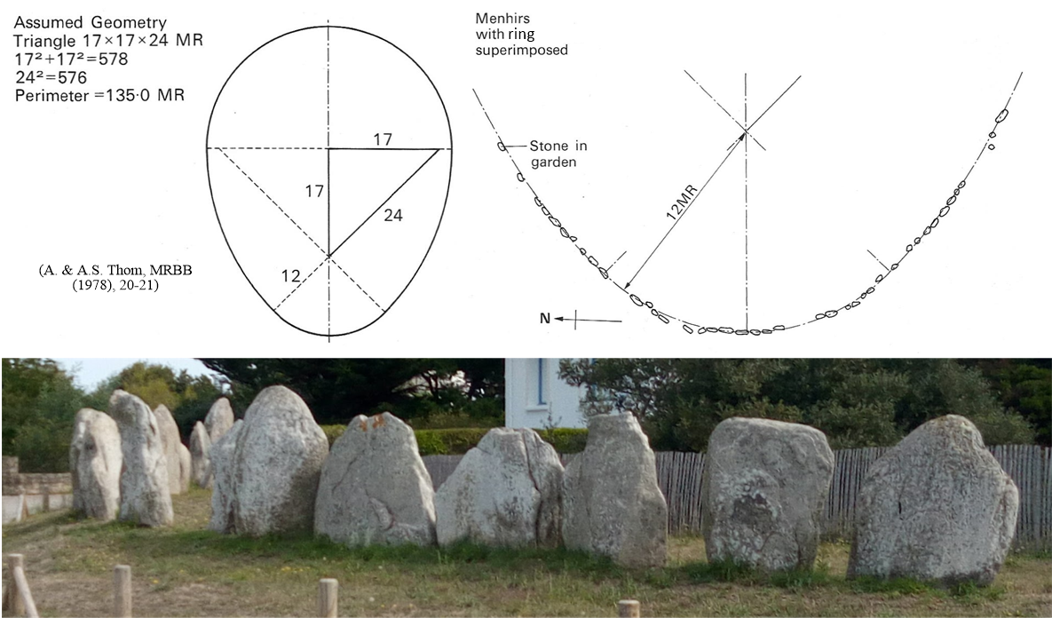
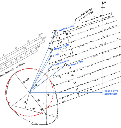
Two key lengths are found at Le Manio and Le Menec: The first, of 4 eclipse years is a day-inch count of the Octon eclipse cycle; the second is a four solar year count that, with the first, forms a triangle, marked clearly by stones at Le Menec. The principles worked out at Le Manio appear fully developed in Le Menec’s western cromlech, including the use of an 8 eclipse year day-inch count, consequently forming a diameter of 3400 megalithic inches which equals in number the days in half a nodal period. The scaling of the Western Alignments is found to be 17 days per metre, a scaling naturally produced by the diagonal of a triple square geometrical construction. A single sloping length on the top of the central stone initiating row 9, indicates a single lunar orbit at 17 days per metre, a length of 1.607 metres. This control of time counting within geometrical structures reveals that almost all of Le Menec’s western cromlech and alignments express a necessary form, so as to represent a megalithic study of (a) circumpolar time as having 365 time units, (b) the moon’s orbit as having 82 times 122 of those units and (c) the variations of successive moonrises over most of a lunar nodal period of 18.6 solar years.

Locmariaquer 1: Carnac’s Menhirs and Circumpolar Stars

Read 1458 times when last published on MatrixOfCreation.co.uk, Wednesday, 16 May 2012 14:22

At megalithic sites, the only alignment of note on the northern horizon has usually been the direction of the north pole or “true” North on the site plan. “Megalithic” cultures worldwide, both the later manifestations in the Americas or the old world cultures of Northwest Europe or Egypt, built structures oriented in a very accurate way to North. The builders of the Great Pyramid for example or of the geo-glyphs of the Amazon rainforest, seemed to have had an unexpectedly good method for determining North, no easy task when a pole star is never exactly north and, in many epochs, there is no star near to the pole.

Continue reading “Locmariaquer 1: Carnac’s Menhirs and Circumpolar Stars”

St Pierre 1: Jupiter and the Moon

The egg-shaped stone circles of the megalithic, in Brittany by c. 4000 BC and in Britain by 2500 BC, seem to express two different astronomical time lengths, beside each other as (a) a circumference and then (b) a longer, egg-shaped extension of that circle. It was Alexander Thom who analysed stone circles in the 20th century as a hobby, surveying most of the surviving stone circles in Britain and finding geometrical patterns within irregular circles. He speculated the egg-shaped and flattened circles were manipulating pi so as to equal three (not 3.1416) between an initial radius and subsequent perimeter, so making them commensurate in integer units. For example, the irregular circle would have perimeter 12 and a radius of 4 (a flattened circle).

However, when the forming circle and perimeter are compared, these can compare the two lengths of a right-triangle while adding a recurring nature: where the end is a new beginning. Each cycle is a new beginning because the whole geocentric sky is rotational and the planetary system orbital. The counting of time periods was more than symbolic since the two astronomical time periods became, by artifice, related to one another as two integer perimeters that is, commensurate to one another, as is seen at St Pierre (fig.3).

Continue reading “St Pierre 1: Jupiter and the Moon”

Durrington Walls and its massive circle of Pits

Recent analysis of animal bones within Durrington Walls indicated, to the archaeologists involved, that people had travelled there from all over the British mainland, along with animals then eaten inside the henge[1]. But what would these people be doing there? It had earlier been suggested that an elite responsible for building Stonehenge lived in a wooden roundhouse within the henge ([2] see figure 1). So, people may have come from elsewhere to help the building works now found between Stonehenge and Avebury.

Figure 1 Reconstruction of the likely roundhouses within the Durrington henge, based on post-hole evidence [2]

More recently, pits have been found [3] within a circular strip that I notice lies between 3168 feet and 4038 feet from Durrington Walls, a boundary 864 feet wide. The pits may contain the material remains of the building elite and perhaps of those workers who died, functioning like nearby barrows but vertically.

This post aims to explain why this might have been done according to a significant geometrical pattern. In the megalithic, numbers played an active role and this perhaps inspired the myth of Atlantis recorded by Plato – the classical Greek writer who transmitted the ancient notion that numbers had a causative role in forming the “world soul”, rather than our usage for number: a means to quantify things within civilized societies or laws of nature.

Continue reading “Durrington Walls and its massive circle of Pits”

The Avebury Square within it’s Southern Circle

Soil resistance work (“geophys”), by archaeologists from the University of Leicester, of the land inside the southern stone circle of Avebury Henge, has revealed more about the Obelisk and lines of standing stones, which appear to have formed a near-square rectangle. Information can be hard to obtain when work is yet to be published but a press release to the Guardian and others many months ago (December 27th 2019) enabled figures from a media set to be viewed with public access. This has enabled me to so some site interpretation, using the (as-yet damned) numerical technique called ancient metrology. My results are fascinating and build upon the megalithic use of counting time as length to track important time-cycles such as the Nodal Period of 6800 days, between lunar maxima and minima, and the Metonic period of both 19 years and 235 lunar months, within which all of the varied orientations of Sun Moon and Sky are recycled.

Figure 1 Avebury Henge from the North with major features labelled
Continue reading “The Avebury Square within it’s Southern Circle”

Silbury Hill: Metrological Key to the Model of the Earth between Stonehenge & Avebury

Archived: 11 August 2012

The exact location of Silbury Hill is as mysterious as the purpose of the Hill itself, a thirty degree cone, only recently with a flat top, overlooking Avebury and the surrounding hills. The Hill figures in John Michell’s model of the Earth between Stonehenge and Avebury in which one quarter of a degree of latitude, between the two henges, appears to have been measured by a type of Persian foot so as to make the number of feet, in between, equal numerically to that required to perfectly model the Earth using 864:866:867 double triangle.

The double triangle model of the size of the Earth between Stonehenge and Avebury

There are 86400 Persian feet of 1.056 feet (south to north) between Stonehenge and Avebury Ridgeway enabling the Avebury henge to be 86600 of these Persian feet from Stonehenge, then to represent the Mean Earth radius (see Initial Article – missing link). The Avebury henge appears to have been specifically tied to the distinct Latitude of 360/7 degrees.

Continue reading “Silbury Hill: Metrological Key to the Model of the Earth between Stonehenge & Avebury”