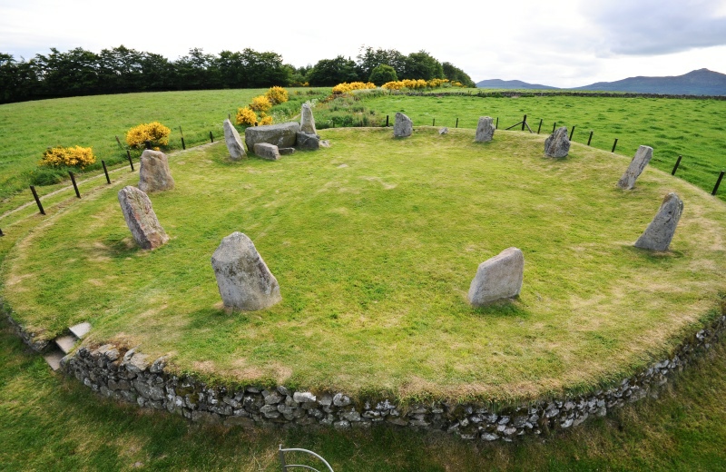
Easter Aquhorthies (i.e. apocathery) has eleven stones in a circle and in between the two south-to-south-west stones is a large (bridging) recumbent stone, more commonly found in Scottish circles and associated (by Alexander Thom) to lunar observatories because, in Scotland at lunar maximum standstill, the moon can rest upon or be hidden by a raised horizon.
Picture by krautrock, a member of megalithic.co.uk in June 2010.
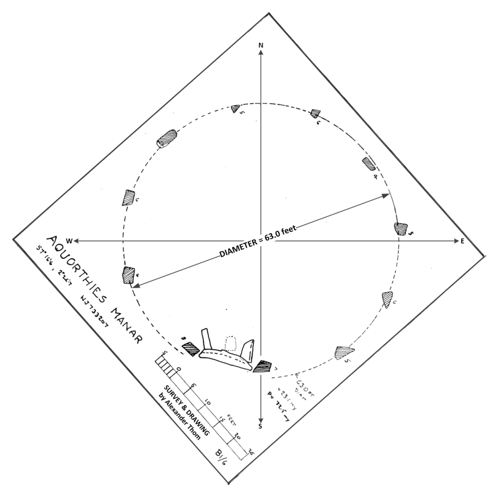
Figure 1 Alexander Thom’s site plan, with cardinal directions and highlighting the diameter .
It is tempting to assume geometry within stone circles and this one invites that by having eleven regularly placed stones,. However, 11 is rarely found in regular geometries or stone circles. But,
Eleven is associated (geometrically) with the simplest approximate ratio for pi, of 22/7 and, being on a circle perimeter 22 units on the perimeter means 7 as the diameter. However, the diameter here is 7 x 9 = 63 so that 7 units of 9 feet in diameter translates into 22 x 9 = 198 feet on the circumference.
The second symbolism of eleven is found in the solar time cycles of 33 years which traditionally references as the Solar Hero cycle as the age when heroes die. 33 years was signified in this way because of an exact alignment, at which Equinox sunrise should repeat on the distant horizon every 33 years. While the solar year is 365 whole days long it takes an extra 32/132 of a day for the Earth’s orbit to complete, and this fraction (of 32/132) depends upon 4 x 33 = 132 losing its 33, 33 years after an earlier Equinox on the horizon. (Note that one did not need to know the data and then calculate, as we do today: instead, observation of in-exact solar risings or settings could notice near exact repetitions occurring after 8 years, but more perfectly after 33 years.
Returning to the circle, the circumference of this stone circle is 198 feet which is 6 x 33 = 198 so that the 11 stones may be referencing 33 solar years.
The 33-year period is strangely linked to the movement of the moon’s nodes, which take 18.618 years (of the nodal period) to progress once around the path of the sun (ecliptic). The area under this precession of the lunar nodes (pi x 18.618^2 = 1,088.970022752789) relative to the earth it orbits, which closely equals the area of a square of side 33 x 33 = 1,089.
The megalithic and ancient world both made monuments conforming to the equal area and equal perimeter geometries and even though the equal area situation is proven unsolvable, one sees that (before the notion of an analytic solution) a perfect example was found of a workable pair of numbers (33 years and 18.618 years) was available as these two very significant astronomical time periods.
If the circle is 63 feet in diameter, then one divided by 14 and multiplied by 11 to obtains the square of equal perimeter: 63 x 11/14 = 49.5, which is 99/2 feet on the side. This can then establish the radius of the circle as 18.618 of the same units: When divided by 33, 99/2 becomes 3/2 which is the unit for the radius of the circle of equal namely 18.618 x 3/2 = 27.927 or nearly 28 feet. Below is a picture showing the square and the circle, equal in area in red while the perimeter of the stone circle is equal in perimeter to the red square.
One can see that the red circle embraces the recumbent stone and its altar-like appendages.
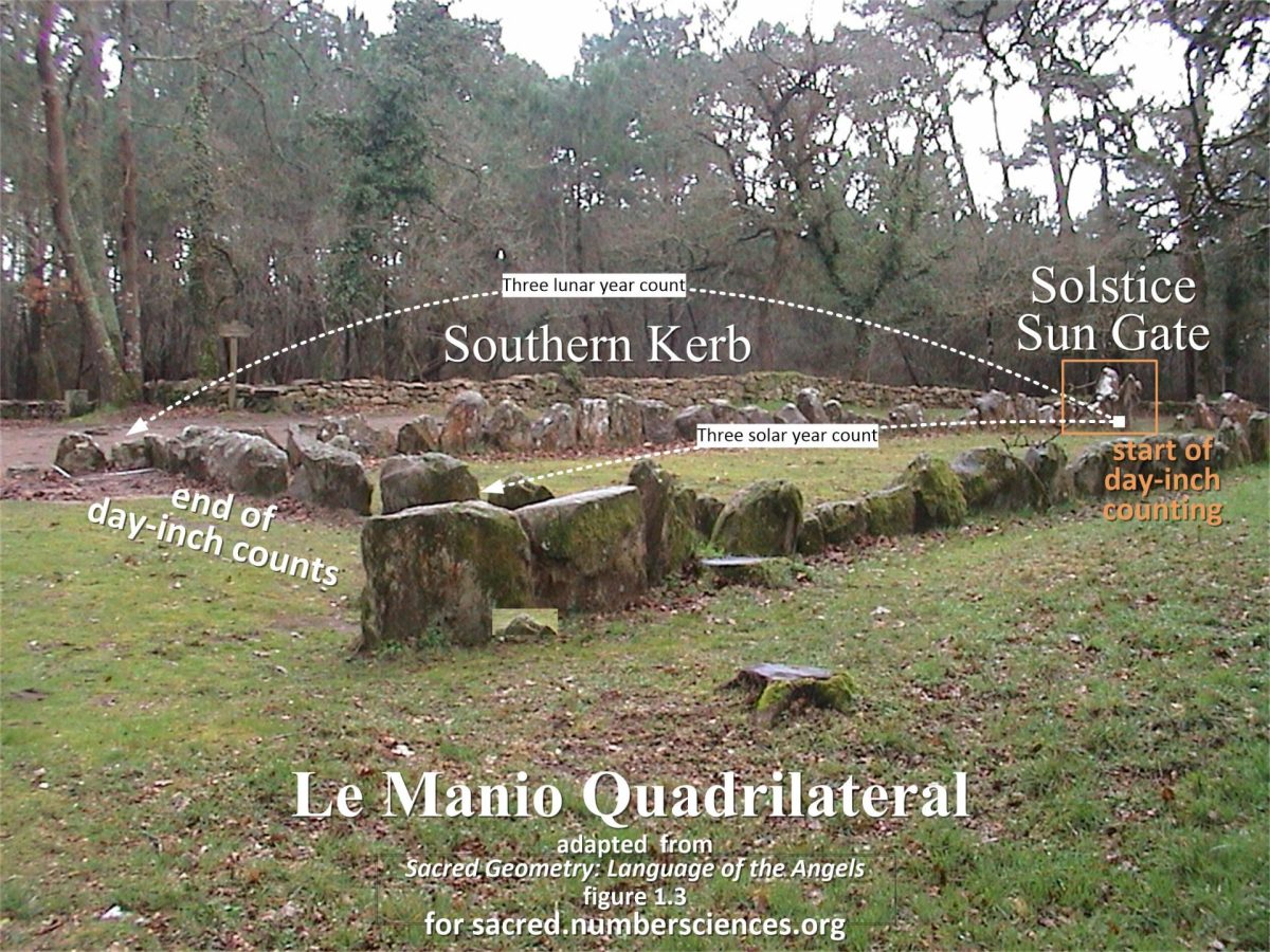
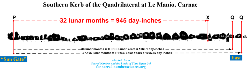
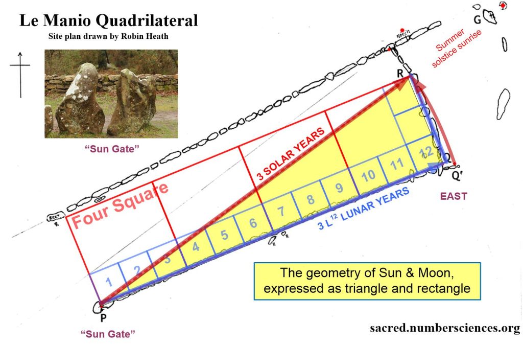
One could ask “if I make a times table of 29.53059 days, what numbers of lunar months give a nearly whole number of days?”. In practice, the near anniversary of 37 lunar months and three solar years contains the number 32 which gives 945 days on a metrological photo study I made of Le Manio’s southern curb (kerb in UK) stones, where 32 lunar months in day-inches could be seen to be 944.97888 inches from the center of the sun gate. This finding would have allowed the lunar month to be approximated to high accuracy in the megalithic of 4000 BC as being 945/32 = 29.53125 days.
Silhouette of day-inch photo survey after 2010 Spring Equinox Quantification of the Quadrilateral.
One can see above that the stone numbered 32 from the Sun Gate is exactly 32/36 of the three lunar years of day-inch counting found indexed in the southern curb to the east (point X). The flat top of stone 36 hosts the end of 36 lunar months (point Q) while the end of stone 37 locates the end of three solar years (point Q’). If that point is the end of a rope fixed at point P, then arcing that point Q’ to the north will strike the dressed edge of point R, thus forming Robin Heath’s proposed Lunation Triangle within the quadrilateral as,
points P – Q – R !
In this way, the numerical signage of the Southern Curb matches the use of day-inch counting over three years while providing the geometrical form of the lunation triangle which is itself half of the simpler geometry of a 4 by 1 rectangle.
The key additional result shows that 32 lunar months were found to be, by the builders (and then myself), equal to 945 days (try searching this site for 945 and 32 to find more about this key discovery). Many important numerical results flow from this.
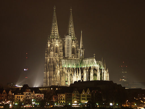
image: The Gothic cathedral of Cologne by night, by Robert Breuer CC-SA 3.0
On the matter of facades of Gothic cathedrals, I hark back to previous work (February 2018) on Cologne cathedral. This was published in a past website that was destroyed by its RAID backup system!
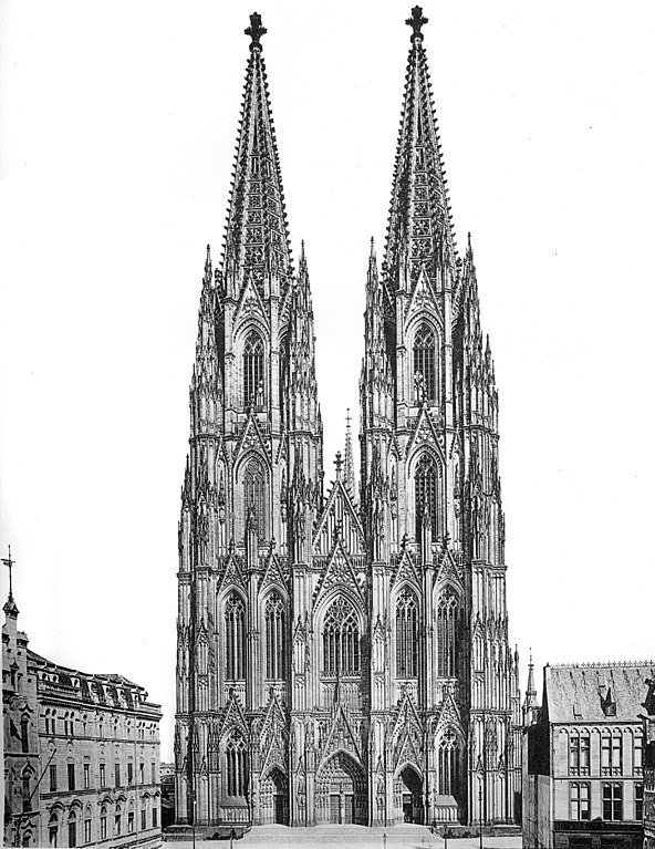
As we have seen with Chartres, some excellent lithographs with scales can often exist online from which one can interpret their sacred geometrical form and even the possible measures used to build that form. The Gothic norm for a facade seem more closely followed at Cologne facade which has two towers of (nearly) equal height.
We saw at Chartres that an underlying geometry using multiple squares may have been used to define a facade and bend it towards a suitable presentation of astronomical time, in a hidden world view that God’s heaven for the Earth is actually to be found in the sky as a pattern of time. This knowledge emerged with the megaliths and, in the medieval, it appeared again in monumental religious buildings built by masons who had inherited a passed-down but secret tradition.
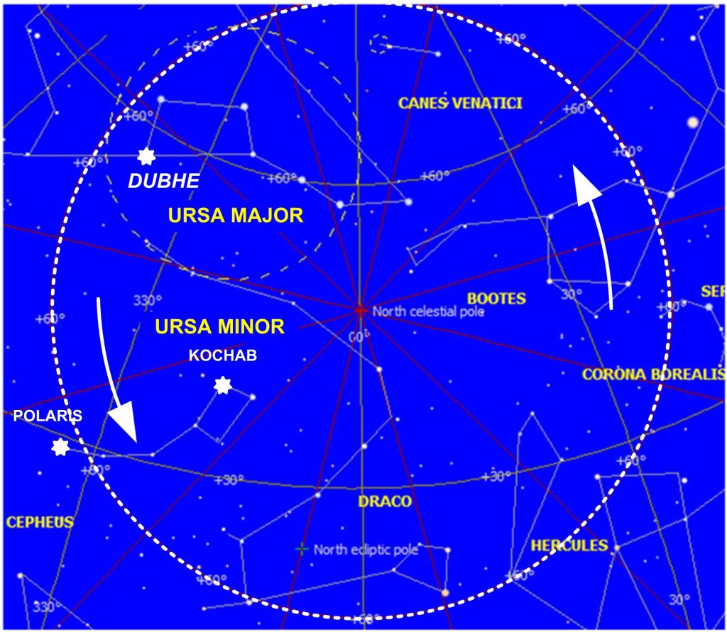
The marker stars within the circumpolar or arctic region of the sky have always included Ursa Major and Ursa Minor, the Great and Little Bear (arctic meaning “of the bears” in Greek), even though the location of the celestial North Pole circles systematically through the ages around the pole of the solar system, the ecliptic pole. In 4000 BC our pole star in Ursa Minor, called Polaris, was far away from the north pole and it reached a quite extreme azimuth to east and west each day, corresponding to the position of the sun (on the horizon in 4000 BCE at this latitude) at the midsummer solstice sunrise. This means angular alignments may be present to other important circumpolar stars in some of the stones initiating the Alignments at Le Menec, when these are viewed from the centre of the cromlech’s circle implicit in its egg-shaped perimeter.
This original “forming circle” of the cromlech could be used as an observatory circle, able to record angular alignments. Therefore the distinctive “table” stone which aligns to the cromlech’s centre at summer solstice sunrise, also marked the extreme angle (to the east) of Polaris, alpha Ursa Minor, our present northern polestar. That is, in 4000 BCE Polaris stood directly above the table stone, once per day – whether visible or not.
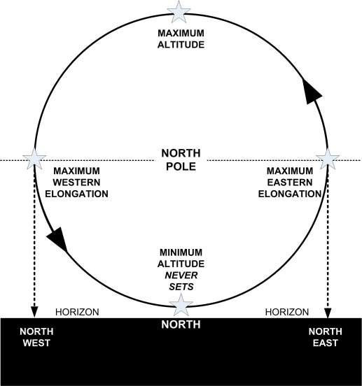
Such a maximum elongation of a circumpolar star is the extreme easterly or westerly movement of the star, during its anti-clockwise orbit around the north pole. Thus, if the northern horizon were raised (figure 5) until it passed through the north pole, the maximum circumpolar positions for a star to east and west would be equally spaced, either side of the north pole. If these extreme positions are brought down to the Horizon in azimuth, the angles between these extremes forms a unique range of azimuths on the ground between (a) the horizon (b) a foresight such as a menhir and (c) an observer at a backsight. Observations of these extreme elongations naturally enable the pole (true north) to be accurately established from the observing point as the point in the middle of that range. A marker stone can usefully locate a circumpolar star at one of these maximum elongations and come to symbolize that important star. A star’s location could have been brought down to the horizon using a vertical pole or plumb bob, between the elongated star and the horizon, at which point menhirs could later be placed, relative to a fixed viewing centre or backsight. This method of maximum elongations would have escaped the atmospheric effects associated with observing stars on the horizon which causes a variable angle of their visual extinction below which stars disappear before reaching the horizon.
Figure 5.The Maximum Elongation of Circumpolar Stars is a twice daily event when, looking at the horizon, the star’s circumpolar “orbit” momentarily stops moving east or west at maximum elongation in azimuth and reverses its motion.
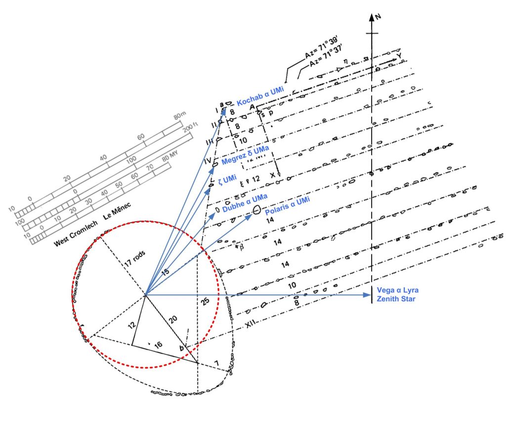
At Le Menec the azimuths of the brightest circumpolar stars, at maximum elongation, appear to have been strongly associated with the leading stones of the western alignments (see figure 6). However, it is likely that only one of these circumpolar stars was used as a primary reference marker, for the purpose of measuring sidereal time at night when this star was visible.
Figure 6 Some of the associations between circumpolar stars and stones in the western alignments. These alignments are all to the maximum easterly elongations, perhaps established during the building of the sidereal observatory and only later formalized into leading stones at the start of different rows. Dubhe was then selected as the primary marker star for the Le Menec observatory.
To achieve continuous measurements of sidereal time from the circumpolar stars requires a simple geometrical arrangement that can draw down to earth the observed position of maximum elongation to east and west for one bright circumpolar star, the observatory’s marker star. A rectangle must then be constructed to the north of the cromlech’s east-west diameter and containing within it the observatory’s northern semicircle. The northern corners must align with, relative to the centre of the circle, the eastern and western elongations of the chosen marker star. For Le Menec the rectangle had to be extended northwards until it reached the first stone of row 6[1]. This stone is aligned, from the centre, to the maximum eastern elongation of Dubhe or alpha Ursa Major. The first stone of row 6 is therefore the menhir marking Dubhe. To the south, the initial stones of further rows all stand on the eastern edge of this rectangle, so that any point on the rectangle’s north face could be brought down, unobstructed, to the circumference of the circle.
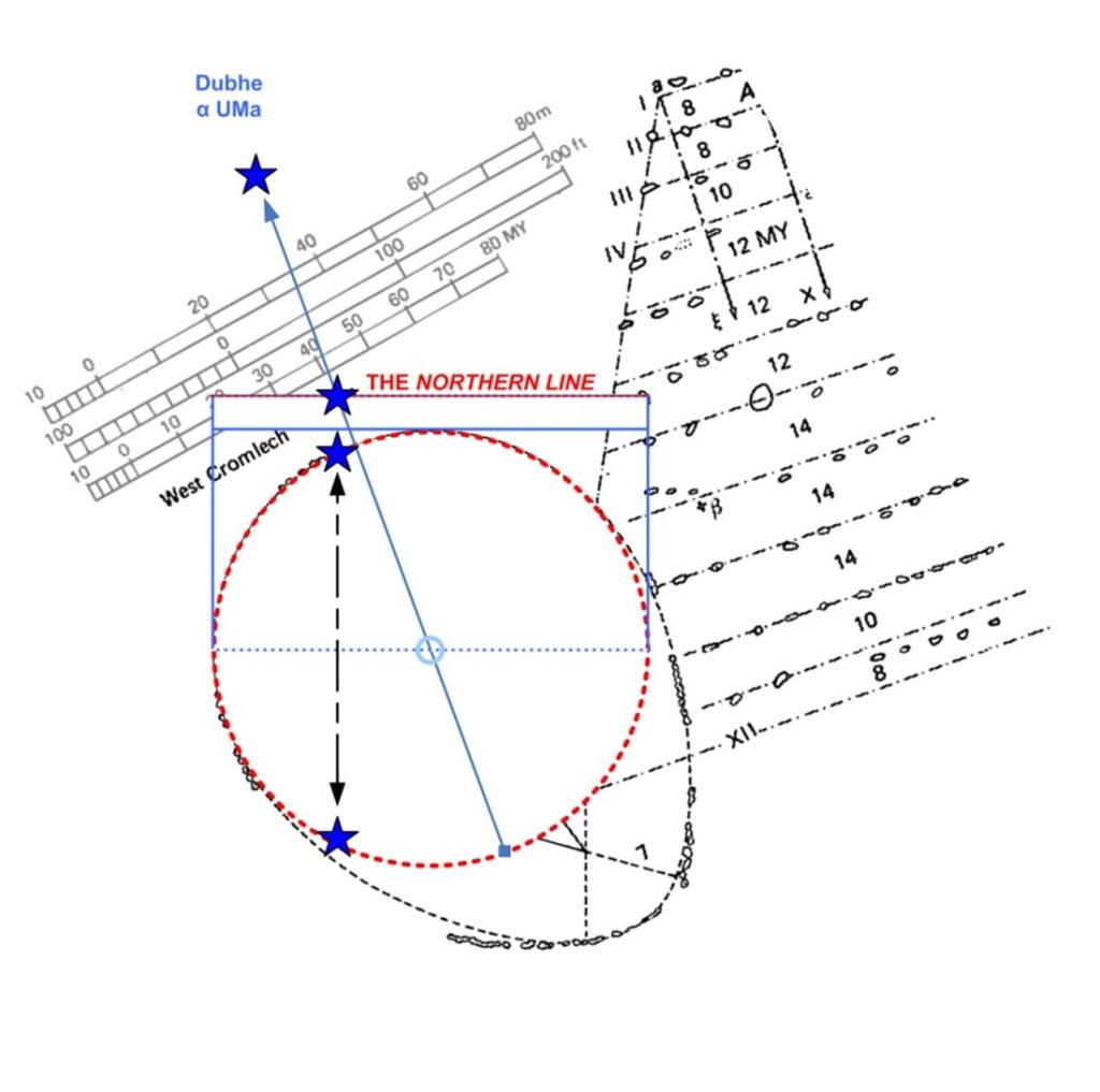
Figure 7 shows how the form of the circumpolar region, within the “orbit” of Dubhe, is repeated by the cromlech’s forming circle. It is also true that the “northern line” then has the same length as the diameter of the forming circle, which has therefore been metrologicallyharmonized with row 6’s initial stone and the alignment to Dubhe in the east.
This arrangement has the consequence that whereverDubhe is (above the northern line and when seen on a sightline passing through the centre of the cromlech) its east-west location in the sky can be brought down, directly south, to two points on the forming circle of the observatory – all due to the star observation having been made upon a length equal to the circle’s diameter (the Northern Line of figures 7 and 8). One of these two points, on the northern or southern semicircle of the observatory, must then correspond exactly to where Dubhe is in its “orbit” around the north pole, as in figure 8.
So, what is being measured here and what would be the significance of having such a capability? Whilst the movement ofall the stars is being accurately measured, using this northern line and forming circle combination, the monument also has a reciprocal meaning. The forming circle also represents the earth’s rotation towards the east, the cause ofthe star’s apparent motion. This is because, when looking north, thefamiliar direction of rotation of the stars, when looking south, is reversed from a rightwards motion to a leftwards, anticlockwise motion. Circumpolar motion therefore directly represents the rotation of the earth. The Dubhe marker star would have represented the movement of a point on the surface of the earth, moving forever to the east. Perhaps more to the point, the eastern and western horizon are moving as two opposed points on its circular path, each moving at about the same angular speedasDubhe. This deepens the view of the forming circle as representing those ecliptic longitudes in which the fixed stars, rising or setting on the eastern and western horizons, are fixed locations on the circle through which these horizons are moving as markers on the circle’s circumference.
These two views, of a moving earth and of a moving background of stars, could be interchangeable when understood and both viewpoints are equally useful and were probably relevant to the operation of this observatory. Whilst the circumpolar stars move around the pole, the eastern and western horizon move opposite each other, running along the ecliptic, as the Earth rotates. The first view enables an act of measurement which would have given astronomers access to sidereal time and the second view provided knowledge of where the eastern and western horizons were located viz a vis the equatorialstars and therefore knowledge of whichpart of the ecliptic was currently rising or setting.
Figure 8 Recreating the circumpolar region with marker star Dubhe at the correct angle on the forming circle of the western cromlech. The star’s alignment on the northern line is dropped to the south so as to touch the two points of the circumference corresponding to that location on the circle’s diameter: one of these will be the angle of Dubhe as seen within the circumpolar sky but now accurately locatable in angle, on the observatory circle.
Dubhe had, in 4000BCE, a fortunate relationship to the circumpolar sky and equatorial constellations which would have been very useful. When Dubhe reached its maximum eastern elongation (marked by the first stone in the sixth row) the ecliptic’s summer solstice point was rising in the east. However, Dubhe’s maximum western elongation did not correspond to the winter solstice, this due to the obliquity of the ecliptic relative to north. It is the Autumn Equinoctal point of the ecliptic that is rising to the east at Dubhe’s maximum western elongation. It was when Dubhe was closest to the northern horizon, that the other, winter solstice point was found rising on the ecliptic. It is important to realize that these observational facts were true every day, even when the sun was not at one of these points within the ecliptic’s year circle.
NEXT:
CONTENTS
This paper proposes that an unfamiliar type of circumpolar astronomy was practiced by the time Le Menec was built, around 4000 BCE.
Today, an astronomer resorts to the calculation of where sun, moon or star should be according to equations of motion developed over the last four centuries. The time used in these equations requires a clock from which the object’s location within the celestial sphere is calculated. Such locations are part of an implicit sky map made using equatorial coordinates that mirror the lines of longitude and latitude. Our modern sky maps tell us what is above every part of the earth’s sphere when the primary north-south meridian (at Greenwich) passes beneath the point of spring equinox on the ecliptic. Neither a clock, a calculation nor a skymap was available to the megalithic astronomer and, because of this, it has been presumed that prehistoric astronomy was restricted to what could be gleaned from horizon observations of the sun, moon, and planets.
Even though megalithic people could not use a clock nor make our type of calculations, they couldusethe movement of the stars themselves, including the sun by day, to track sidereal (or stellar) time provided they could bring this stellar time down to the earth. This they appear to have done at Le Menec, using the cromlech’s defining circle, which was built into its design so as to become a natural sidereal clock synchronized to the circumpolar stars.
Figure 4 The Circumpolar Stars looking North from Le Menec in 4000 BCE, when the cromlech was probably built. There is no north star but marker stars travel anti-clockwise and these can align to foresights at their extreme azimuthal “elongation”, as explained below.
The word sidereal means relating to stars and, more usually, to their rotation around the earth observer as if these stars were fixed to a rotating celestial sphere. This rotation is completely reliable as a measure of time since it is stabilized by the great mass of the spinning earth. However, in a modern observatory this sidereal time must be measured indirectly using an accurate mechanical or electronic clock. These clocks can only parallel the rotation of the earth in a sidereal day, which is just under four minutes less than our normal day. Nonetheless, a sidereal day is again given 24 ‘hours’ in our sky maps and it is these hours which are then projected upon the celestial sphere as hours (minutes and seconds) of Right Ascension, hours in the rotation of the earth during one sidereal day.
This video introduces an article on a Scottish iron-age stone tower or brock which encoded the size of the Earth.
You can view the full article on sacred dot number sciences dot org, searching for BROCK, spelt B R O C H.
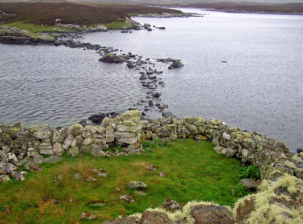
In the picture above [1] the inner profile of the thick-walled Iron-Age broch of Dun Torceill is the only elliptical example, almost every other broch having a circular inner court.
Torceill’s essential data was reported by Euan MacKie in 1977 [2]: The inner chamber of the broch is an ellipse with axes nearly 23:25 (and not 14:15 as proposed by Mackie).
The actual ratio directly generates a metrological difference, between the major and minor axis lengths, of 63/20 feet. When multiplied by the broch’s 40-foot major axis, this π-like yard creates a length of 126 feet which, multiplied again by π as 22/7, the simplest accurate approximation to the π ratio, between a diameter and circumference of a circle, as used in the ancient and prehistoric periods., generates 396 feet. If each of these feet represented ten miles, this number is an accurate approximation to the mean radius of the Earth, were it a sphere.
If we take the size of the moon in that model, as being 3/11 of 396 feet this would give a circle radius 108 feet and one can see that, using the moon, the outer perimeter of the brock was probably elliptical too.